

The Trails

The Musquodoboit Trailway begins at the Caboose Information Centre at the Musquodoboit Railway Museum, crosses highway 357, passes the arena and ball fields and links up with the official trailhead by the parking lot on Park Road. The 130 foot trestle bridge offers a scenic view of the Musquodoboit River and its broad flood plains...see more

The Admiral Lake Loop Trail originates at 1.7 km along the Musquodoboit Trailway as measured from Park Road. The trail climbs into an open area of blueberry bushes and low saplings, reminders of the 1973 forest fires that swept through this area...see more

The Bayer Lake Loop Trail originates on the Admiral Lake Trail. From Park Road, proceed 1.7 km along the Musquodoboit Trailway to the Admiral Lake Loop trailhead; then follow this trail for approximately 170 m to the Bayer Lake Loop trailhead...see more

Take the Musquodoboit Trailway for
2.6 km from Park Road to the north end
of the Admiral Lake Loop trail. Follow
the approach to the Admiral Lake Junction bearing left onto the
wilderness trail...see more

Take the Musquodoboit Trailway from the Gibraltar Parking Lot on Highway 357 to the south end of the Gibraltar Rock Loop trail (1.1 km). Follow the Gibraltar Rock Loop trail connector upward and at the Gibraltar Junction, veer right onto the North Granite Ridge trail. The trail winds its way for a distance of 9.3 km along the granite ridge, traversing areas of old growth hemlock...see more

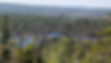
From the Gibraltar trailhead parking lot on Highway 357 proceed south for about 100 m to the northern entrance of this 1.3 km loop trail. It climbs steeply to Gibraltar Rock where the lookoff offers a bird's eye view of the river and road below. To the north the view is of the Shubenacadie glacial spillway...see more
Getting Here
From Dartmouth follow Highway 107 and then Highway 7 to Musquodobit Harbour. Turn left off Highway 7 just beyond the Musquodoboit Harbour Railroad Museum and Tourist Bureau onto Highway 357. Continue along the 357 to Park Road. Turn right and proceed to the Trailhead on your left.
Trails can be seen here, listed from South to North.
-
AllTrails (individual trail maps)
-
OPEN alltrails.com/explore/trail/canada/nova-scotia/musquodoboit-trail
-
OPEN alltrails.com/trail/canada/nova-scotia/skull-rock-trail
-
OPEN alltrails.com/explore/trail/canada/nova-scotia/bayer-lake
-
OPEN alltrails.com/explore/trail/canada/nova-scotia/admiral-lake-trail-loop
-
OPEN alltrails.com/trail/canada/nova-scotia/jessies-diner-loop
-
OPEN alltrails.com/explore/trail/canada/nova-scotia/south-granite-ridge-trail
-
OPEN alltrails.com/trail/canada/nova-scotia/south-granite-ridge-trail-and-musquodoboit-loop
-
OPEN alltrails.com/explore/trail/canada/nova-scotia/north-granite-ridge-trail
-
OPEN alltrails.com/explore/trail/canada/nova-scotia/gibraltar-rock-loop
-
-
TrailForks (all trails in one view)